![]()
A vibrant territory

Eco-Vallée aerial view © NCA / Pierre Behar - A Vol d'Oiseau


Ideally situatedbetween sea and mountains, with its mix of urban settings and country landscapes, and its population of more than 100 000 inhabitants, the area of the plaine du Var is prime territory for an innovative development project.
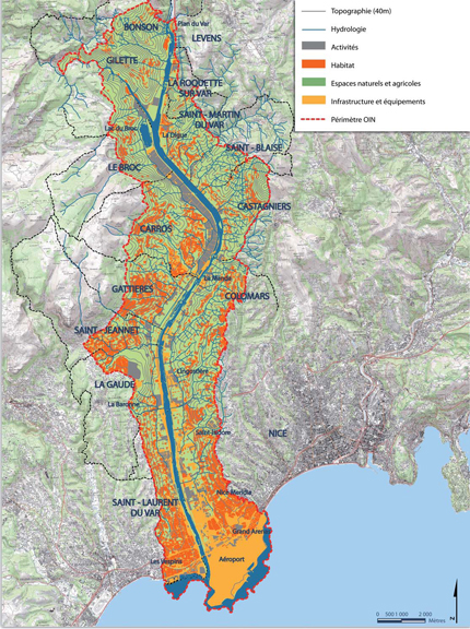
An area to be rethought
The plaine du Var was, for a long time, Nice’s “garden”, with its cultures sustaining an every growing population, especially at the beginning of the XXth century with the birth of the French Riviera’s “Côte d’Azur”. The 1960s were marked by random development: The rich lands were slowly impeded on by constructions, here, an urban settlement with roadways, there, industrial zones or commercial halls, while housing, here and there, slowly started to cover the hillsides. The river itself, domesticated by dikes, started to dig deeper into its bed. Agricultural activities diminished, leaving the place to industrial ones, and the plaine du Var became a sort of « back city », an economic suburb of the coast line, with an anarchic development.
And yet, with its outstanding location set between the coastline and the mountain peaks, at the entrance of the Nice metropolis, with its rich natural resources as well as its architectural heritance, and with its population of 116 000 inhabitants, this territory deserved better! An innovative development project imposed itself.
A shared diagnosis
Over the past ten years, several organisms have carried out studies on the strengths and weaknesses of the plaine du Var: the Center of Technical Studies for the Mediterranean Equipment (Minister of Equipment, Transport and Planning), the French Interministerial Delegation for Territorial Planning and Regional Attractiveness (DATAR Délégation Interministérielle à l'Aménagement du Territoire et à l'Attractivité Régionale), the Nice Côte d’Azur metropolis, in prevision of its territorial coherence scheme (SCOT Schéma de Cohérence Territoriale )…
As of 2003, the Territorial Planning Directive (DTA Directive Territoriale d’Aménagement) for the Alpes-Maritimes identified the plaine du Var as a « strategic sector for development », underlining the importance of the environmental dimension.
In 2009-2010, three planning and development studies, called « definition studies » were mandated with international teams of experts.
All these studies helped reinforce the diagnosis and define the key orientations which were largely agreed upon: the need to restore, preserve and bring value to an exceptional, but altered, territory.